Comparison of Interpolation Methods for Mapping Water Quality in Seloromo Reservoir
DOI:
https://doi.org/10.51264/inajl.v6i1.85Keywords:
Interpolation, Inverse distance weighting, Kriging, SplineAbstract
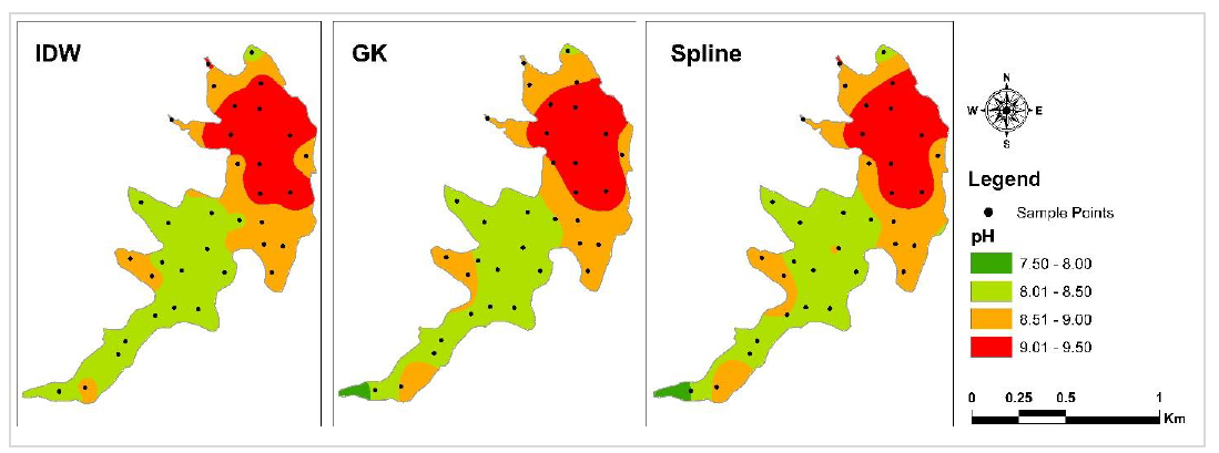
Spatial interpolation is GIS modeling to estimate the value of an unmeasured location point based on measurements at another location. However, research on choosing the best interpolation method for a sample to become a continuous map is still limited. The main objective of this study is to compare three interpolation methods to show the spatial distribution map of water quality in Seloromo Reservoir, Pati Regency. Water quality measurements in terms of pH, EC, and TDS parameters consist of 50 sample points for each parameter. Water sampling was conducted in February 2023 from morning to afternoon. The three interpolation methods include inverse distance weighting (IDW), Gaussian kriging (GK), and spline. The results show that each interpolation method used will result in different interpolation maps. The best interpolation method in this study is inverse distance weighting (IDW). The IDW method has the best R-Square (pH 0.824; EC 0.85; TDS 0.873) and RMSE (pH 0.146; EC 0.93; TDS 0.563) values compared to the other two methods. This research is limited to comparing the results of mapping water quality distribution.
References
BBWS Pemali Juana. (2019). SID Rehabilitasi Daerah Irigasi Gembong.
Belkhiri, L., Tiri, A., & Mouni, L. (2020). Spatial Distribution of The Groundwater Quality Using Kriging and Co-kriging Interpolations. Groundwater for Sustainable Development, 11(August). https://doi.org/10.1016/j.gsd.2020.100473
Gong, G., Mattevada, S., & O’Bryant, S. E. (2014). Comparison of the Accuracy of Kriging and IDW Interpolations in Estimating Groundwater Arsenic Concentrations in Texas. Environmental Research, 130, 59–69. https://doi.org/10.1016/j.envres.2013.12.005
Hasan, M., Kurnia Sunaryo, D., & Jasmani. (2020). Pemodelan Potensi Air Tanah Untuk Pengelolaan Sumber Daya Air Menggunakan Sistem Informasi Geografis: Studi Kasus di Daerah Pasigala (Palu, Sigi dan Donggala). Institut Teknologi Nasional Malang.
Indriani, W., Hutabarat, S., & A’in, C. (2016). Status Trofik Perairan Berdasarkan Nitrat, Fosfat, dan Klorofil-a di Waduk Jatibarang, Kota Semarang. Diponegoro Journal of Maquares, 5(4), 258–264.
Jaffar, A., M. Thamrin, N., Amin Megat Ali, M. S., Farid Misnan, M., Mohd Yassin, A. I., & Mohamed Zan, N. (2022). Spatial Interpolation Method Comparison for Physico-chemical Parameters of River Water in Klang River using MATLAB. Bulletin of Electrical Engineering and Informatics, 11(4), 2368–2377. https://doi.org/10.11591/eei.v11i4.36155
Khouni, I., Louhichi, G., & Ghrabi, A. (2021). Use of GIS Based Inverse Distance Weighted Interpolation to Assess Surface Water Quality: Case of Wadi El Bey, Tunisia. Environmental Technology and Innovation, 24, 101892. https://doi.org/10.1016/j.eti.2021.101892
Kimleang, C., Sok, T., Chan, R., Sokly, S., Heejun, Y., Chihiro, Y., Layheang, S., & Chantha, O. (2017). Assessment of Spatial Interpolation Methods to Map Water Quality in Tonle Sap Lake. The 2nd International Symposium on Conservation and Managment of Tropical Lakes, October, the 2nd International Symposium on Conservation an.
Li, J., & Heap, A. D. (2011). A Review of Comparative Studies of Spatial Interpolation Methods in Environmental Sciences: Performance and Impact Factors. Ecological Informatics, 6(3–4), 228–241. https://doi.org/10.1016/j.ecoinf.2010.12.003
Mirzaei, R., & Sakizadeh, M. (2016). Comparison of Interpolation Methods for the Estimation of Groundwater Contamination in Andimeshk-Shush Plain, Southwest of Iran. Environmental Science and Pollution Research, 23(3), 2758–2769. https://doi.org/10.1007/s11356-015-5507-2
Murphy, R. R., Curriero, F. C., & Ball, W. P. (2010). Comparison of Spatial Interpolation Methods for Water Quality Evaluation in the Chesapeake Bay. Journal of Environmental Engineering, 136(2), 160–171. https://doi.org/10.1061/(asce)ee.1943-7870.0000121
Nurruhwati, I., Zahidah, & Sahidin, A. (2017). Kelimpahan Plankton di Waduk Cirata Provinsi Jawa Barat. Jurnal Akuatika Indonesia, 2(2), 102–108.
Ogbozige, F. J., Adie, D. B., & Abubakar, U. A. (2018). Water Quality Assessment and Mapping using Inverse Distance Weighted Interpolation: A Case of River Kaduna, Nigeria. Nigerian Journal of Technology, 37(1), 249. https://doi.org/10.4314/njt.v37i1.33
Pankalakr, S. S., & Jarag, A. P. (2016). Assessment of Spatial Interpolation Techniques for River Bathymetry Generation of Panchganga River Basin Using Geoinformatic Techniques. Asian Journal of Geoinformatics, 15(3), 9–15. http://203.159.29.7/index.php/journal/article/view/240
Pasaribu, J. M., & Haryani, N. S. (2012). Perbandingan Teknik Interpolasi DEM SRTM dengan Metode Inverse Distance Weighted (IDW), Natural Neighbor dan Spline. Jurnal Penginderaan Jauh, 9(2), 126–139.
Prasetya, D. A., Santikayasa, I. P., & Azizi, I. H. (2021). Analisis Indeks Pencemaran Airtanah di DKI Jakarta dengan Interpolasi Spasial. Jurnal Teknik Sipil Dan Lingkungan, 6(3), 177–186. https://doi.org/10.29244/jsil.6.3.177-186
Prasetyo, B. A., Muawanah, M., Mardianto, L., & Lubis, M. Z. (2022). Distribusi Spasial Kualitas Perairan dan Hubungannya dengan Aktifitas Budidaya Perikanan di Teluk Lampung. Journal of Science and Applicative Technology, 6(1), 1. https://doi.org/10.35472/jsat.v6i1.897
Santoso, A. A., Sudarsono, B., & Sukmono, A. (2017). Analisis Pengaruh Tingkat Bahaya Erosi Daerah Aliran sungai (DAS) Bengawan Solo Terhadap Total Suspended Solid (TSS) di Perairan Waduk Gajah Mungkur. Jurnal Geodesi Undip, 6(4), 463–473.
Sejati, S. P. (2017). Karakteristik Sumber Daya Airtanah Dangkal di Kecamatan Cangkringan Kabupaten Sleman Provinsi Daerah Istimewa Yogyakarta. Media Komunikasi Geografi, 18(2), 166–177.
Soeprobowati, T. R., Jumari, Hariyati, R., & Gell, P. (2019). Paleolimnology Record of Human Impact on a Lake Ecosystem: The Case of Shallow Lakes in Central Java. IOP Conference Series: Earth and Environmental Science, 276(1), 0–8. https://doi.org/10.1088/1755-1315/276/1/012015
Soraya, A. (2021). Pengelompokan Kualitas Air di Kota Pontianak menggunakan Metode Ward dan Single Linkage. Jurnal Buletin Ilmiah Mat. Stat. Dan Terapannya (Bimaster), 10(1), 19–24.
Srinidhi, N. S., Reddy, M. P., & Reddy, A. M. (2022). GIS based approach for the Assessment of Water Quality of the Biodiversity Heritage Site of India-the Ameenpur Lake, Hyderabad. Research Journal of Chemistry and Environment, 26(4), 152–162. https://doi.org/10.25303/2604rjce152162
Triadi, L. B., Adji, F. F., & Dhiaksa, A. (2016). Dampak Dinamika Muka Air Tanah Pada Laju Dan Waktu Subsiden Lahan Rawa Gambut Tropika. Jurnal Teknik Hidraulik, 7(2), 163–178.
Wu, Z., Lai, X., & Li, K. (2021). Water Quality Assessment of Rivers in Lake Chaohu Basin ( China ) Using Water Quality Index. Ecological Indicators, 121, 107021. https://doi.org/10.1016/j.ecolind.2020.107021
Xie, Y., Chen, T. Bin, Lei, M., Yang, J., Guo, Q. J., Song, B., & Zhou, X. Y. (2011). Spatial Distribution of Soil Heavy Metal Pollution Estimated by Different Interpolation Methods: Accuracy and Uncertainty Analysis. Chemosphere, 82(3), 468–476. https://doi.org/10.1016/j.chemosphere.2010.09.053
Downloads
Published
Issue
Section
License
Copyright (c) 2025 Rofiana Budi Ayumi Sita Dewi

This work is licensed under a Creative Commons Attribution 4.0 International License.